Network modeling is a technique that is widely used to understand the impact of transportation policies. Referring to the 4-step modelling approach, this analysis technique consists of four consecutive steps, namely i) trip generation, ii) trip distribution, iii) modal split, iv) trip assignment [1]. The trip generation step relates to the number of trip generation and attraction in a particular zone, while trip distribution step analyzes the origin and destination of the traffic. After the two steps above have been completed, the next step is modal split, which analyzes the proportion or probability of using certain modes by the trips. For road transport, the modal split is usually distributed into car, motorcycle, bus, and other types of road/rail transport. Finally, the trips, which has contained information on its number, its origin-destination, and its modal split, are assigned to a road network model. The road network performance is then analyzed based on several indicators, e.g. traffic volume, travel time, average speed, trip length, volume-capacity ratio, etc.
In order to assess the impact of transport policies, the modeler usually tries to find an approach to represent the policies in the model by modifying the road network model, adjusting the number of trip generation, applying different proportion of modal split, etc. and see how it impacts the road network performance. The standard procedure is by comparing the road network performance for the do-something scenario (the condition where the analyzed transport policies is applied), and do-nothing scenario, where no new policy is applied.
For the past two years, research has been carried out to understand the impact of transport policies in West Java Province, Indonesia. For instance, a study by Ayuningtyas et al. analyzes the impact of a range of transport policies to road network performance in Bandung City, Indonesia [2]. Bandung City itself is one of the most populous cities in Indonesia and the core of Bandung Metropolitan Area [3]. This has resulted in traffic congestion and hence transport policies are needed to alleviate the problem. The transport policies that are explored in this study are: i) the development/upgrade of a new bus terminal, ii) the development of an inner-city toll road, iii) the addition of new minibus lines. Scenarios are then developed by combining those transport policies.
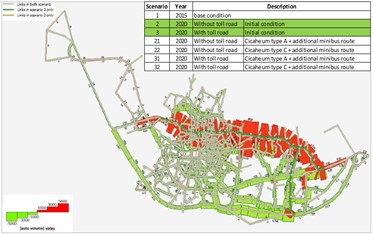
Figure 1 Traffic Shift to the Inner-City Ring Road
The result shows that the development of an-inner city ring road will significantly impact the road-network performance in Bandung City as shown in the Figure 1. By comparing the do-nothing and do-something scenario, a large portion of traffic will shift from many road segments (shown by the green bar) to the inner-city ring road (shown by the red bar). This shift results in higher average speed and lower average volume-capacity ratio for the whole Bandung City Road Network.
Another study by Maulana and Farda also used the network modeling approach to understand the impact of collector road widening of road network in the southern area of West Java Province [4]. This includes 6 regencies, namely Sukabumi, Cianjur, Garut, Tasikmalaya, Pangandaran and Ciamis. Each of these regencies has its own unique economic commodities, including industry and tourism. Therefore, improving the accessibility will support the economic growth in this area. In the study, the accessibility is measured by volume capacity ratio, travel time, network average speed and trip length.
Looking at the current condition, the road network performance of the west java southern area is still good. This is reflected by the volume-capacity ratio lower than 0.85. However, through forecasting, a significant portion of road segment will have volume-capacity ratio more than 0.85 due to the population and traffic increase. This strengthen the case to explore the impact of collector road widening to road network performance. By using the 4-step network modeling approach, the policy is expected to improve road network performance until year 2039. This can be seen in Figure 2 where the do-something scenario, in which the road widening policy is applied, has fewer “red links”, compared with the do-nothing scenario. The “red links” itself represent road segment with volume-capacity ratio higher than one.
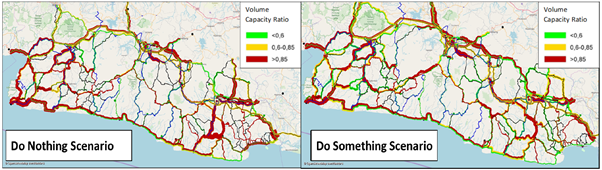
Figure 2 Road Network Performance Comparison Between the Do-Nothing Scenario (No Road Network Widening) and Do-Something Scenario (With Road Network Widening.
The network modeling, therefore, is a useful tool for policy makers and transport stakeholders to assess the impact of transport policies. This is to make sure that, before being implemented, the policy makers are convinced that the proposed policies will create the intended impact and will not become and unnecessary spending.
References
[1] J. de D. Ortúzar and L. G. Willumsen, Modelling Transport. Chichester, UK: John Wiley & Sons, Ltd, 2011.